A UNIQUE SURVEY MONUMENT – WISCONSIN’S STATE CAPITOL
The idea of writing a story along with accompanying pictures of an interesting survey monument at first seemed like a difficult task. Even with years of field experience, most monuments have never been found to be very picturesque. But wait a minute, we do indeed have one to talk about. It is in fact Wisconsin’s State Capitol. The very center of its rotunda represents the section corner common to Sections 13, 14, 23, and 24, Township 7 North, Range 9 East, 4th Principal Meridian, Northwest Territory.
The December 1834 field notes of deputy surveyor Orson Lyon indicate that he headed north between sections 23 and 24, 40 chains to the quarter section corner “in lake”. (Surveyors back then could walk on water!) Continuing north at 51.28 chains he set a post on the north side of lake, tying it in 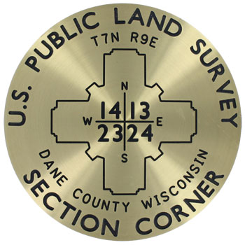 to an 18” hickory and an 11” black oak. He continued north, and at 80 chains set the land as “rolling and 2nd rate”. Little did he realize that 72 years later the location of this plain old wood post would be marked with Wisconsin’s present-day Capitol. It lies on an isthmus running in a northeast-southwest direction between Lakes Monona (“3rd Lake”) and Mendota (“4th Lake”) on the north.
In researching the records, we were fortunate to have, within two blocks of the Capitol, the offices of the Board of Commissioners of Public Lands. There we found the original field books and a map of the township. But one thing remained a mystery: How in the world did Orson Lyon maintain a line of direction and distance when encountering the “3rd Lake” as he came up from the south? If the lake had been frozen over, we’d have the answer. Obviously, the original field notes, which have been preserved, were not prepared on the spot as the crew pressed onward. Mr. Lyon would have kept separate running notes and calculation sheets as he traversed around the lake, and then calculated his position on the far side. A second and more likely scenario might have been to establish a base line, say 10 chains to the east or west of the already established northbound section line, and at each end of this base line measured the angle to a distinct point at the far end of the lake. He then could compute its location – having two angles and the included side.
Oh, how they could have used GPS back then, and two-way radios to direct a lone flagman as he tried to communicate with the rest of the crew at the South end of the lake. We suspect that those “original notes” we find in the preserved field books were in fact the second generation of notes, and were prepared in the evening under candle light. The deputy surveyor was evidently not required to file his “scratch” notes and calculation work sheets while performing the surveys of the public lands at that time. However, in later years as the Public Land surveys moved westward, such notes were preserved and can generally be found today in those survey files.
So is the rotunda precisely centered on the Section Corner as intended? That was certainly the intention of George B. Post, architect for the state’s third capitol. The second capitol had been destroyed by fire in 1904. A drawing in the Capitol’s archives shows that the new Capitol’s center was to be placed at the center of the public square, which in turn was centered on the section corner. Members of the Madison Chapter of the Wisconsin Society of Land Surveyors (WSLS) have had a keen and ongoing interested in the relationship between the two positions. They have done extensive voluntary research, both in office and field, to reconstruct the section lines, and the street centerlines which fan out in six directions. In 1985, ceremonies were conducted in conjunction with the 200th Anniversary of the Public Land Survey System. With television and newspaper coverage, using an antique compass and chain, the Chapter reenacted the setting of the section corner with a brass disc. However, the Capitol Building commissioners rejected the idea of epoxying the disk onto the marble floor.
As the precise location of the section corner, it depends on which combination of monuments and street line extensions one might use to reset the corner. Relative to the massive size of the building and its rotunda, it can be safely said that its center is well within an acceptable error ellipse generated from the chapter’s measurements and computations.
In the meantime, WSLS is reviewing efforts to place a brass marker made by Berntsen International, marking the section corner on the floor directly below the Capitol’s main floor. An exhibit describing this unique survey monument, along with other surveying memorabilia is also being prepared for display in the Capitol’s museum on the sixth floor.
─ Harold S. Charlier, Executive Director, Wisconsin Society of Land Surveyors, Waukesha, Wisconsin
Originally published in Lasting Impressions - A Glimpse into the Legacy of Surveying -Copyright © 2006 by Berntsen International, Inc.