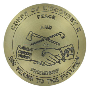
Berntsen Marker Commemorates the Lewis and Clark Bicentennial Celebration
On January 18, 1803, President Thomas Jefferson confidentially requested $2,500 from Congress to establish the Corps of Discovery. This company, later known as the Lewis and Clark Expedition, became foundational to Jefferson’s vision of national expansion and development. This January, the Thomas Jefferson Foundation, in partnership with the National Park Service and others, commemorate Lewis and Clark’s  journey, industry and discovery.
On the trail, Lewis and Clark actively surveyed and mapped their daily positions. By the end of the Expedition, they had successfully charted large parts of the Rocky Mountains, the Great Plains, and the Columbia River watershed.
Berntsen is proud to have been chosen to produce a marker commemorating the survey work of Lewis and Clark. This marker was set on October 14, 2002, on the West Lawn of Thomas Jefferson’s home, Monticello. Dan Jordan, president of the Thomas Jefferson Foundation, said of the marker, “It’s a wonderful tribute to Jefferson’s interest in science and a tribute to Jefferson’s vision of Lewis and Clark’s journey”. Representatives from the American Congress on Surveying and Mapping; Leica Geosystems; the National Oceanic and Atmospheric Administration (NOAA); Thales Navigation; Topcon Positioning Systems, Inc., Trimble Navigation, Ltd; and the Virginia Association of Surveyors participated in the celebration.
In the week following the installation, NOAA’s National Geodetic Survey and Global Positioning System (GPS) manufacturers Leica, Thales, Topcon, and Trimble positioned the marker to an accuracy of one-half inch relative to the National Spatial Reference System. The preliminary coordinates are:
NAD 83 (1993)
38-00-35.57269 N
78-27-12.91469 W
NAVD 88
Elevation – 263-97 m (866.0 ft.)
The engraving on the 12-inch diameter brass marker is taken from the Jefferson peace medal. As they crossed the country, Lewis and Clark presented these medals, called “marks of friendship” by Jefferson, to American Indian chiefs and warriors. A profile of Jefferson is shown on the obverse side of the medal, surrounded by the inscription, “TH. JEFFERSON PRESIDENT OF THE U.S. A.D. 1801.” The reverse side of the medal has the inscription “PEACE AND FRIENDSHIP” and shows the image of clasped hands with a crossed tomahawk and peace pipe above them.
The marker will be officially dedicated on January 14 at Monticello during the Lewis and Clark Exposition, “Jefferson’s West”. More information on this event is available at http://www.monticello.org.
Similar commemorative markers will be placed across the continent along Lewis and Clark’s route, ending at Fort Clatsop National Memorial in Astoria, Oregon, the site of the Expedition’s westernmost base camp. More information on the Lewis and Clark National Historic Trail and the National Park Service is available at http://www.nps.gov/lecl/index.htm
Story written by Nikki Case, NOAA
Originally published in the Berntsen SurveyLog Volume 14, No. 1 (January, 2003)