Remonumenting the Four Corners
The Four Corners Monument is located at an elevation of 5,000 feet above sea level. It is the only place in the United States where four states (Arizona, Colorado, New Mexico, and Utah) meet. It’s interesting to note that since three of the four corners are owned by the Navajo Nation and the fourth is owned by the Ute Mountain Utes, the four states don’t actually meet.
HISTORY
The first survey in this area was the survey of the north boundary of New Mexico Territory in 1868 by Ehud N. Darling. Under his contract, dated May 22, 1868, he was instructed to survey the 37th Parallel of North Latitude, commencing at the 103º degree and terminating at the 109º degree to West Longitude from Greenwich. Darling commenced his survey at the northeast corner of New Mexico on July 19, 1868 and 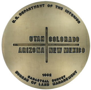 completed the survey on November 18, 1868. He covered the 331 miles and 60 chains in 123 days. Darling’s terminal monument, which served both as his Astronomical Station No. 11 and the corner of the Territories of Colorado, New Mexico, Arizona, and Utah, was a sandstone 5 feet 10 inches in length by 18 inches by 10 inches, set 2-1/2 feet in the ground, in a circular mound of stone 7 foot base by 3 feet high.
In 1875, U.S. Deputy Surveyor, Chandler Robbins, was contracted to survey the line between the Territories of Arizona and New Mexico. This line is in the meridian determined by reference to a landmark peak called “The Needles” by the Wheeler survey of 1874. Robbins called it “the southwest needle point of Wilson’s Peak”. Today, this prominent peak is known as Shiprock. The boundary line was run west and north to the point where the 32nd Meridian west of Washington D.C. intersects the south boundary of Colorado. The point established by Robbins was 1 mile 45 chains east of the mark that had been established by Darling in 1868 as the southwest corner of Colorado. Robbins’ point was accepted, and thus became the only monument in the United States marking the common corner of four states – Utah, Colorado, New Mexico and Arizona.
Rollin J. Reeves, U.S. Surveyor, duly identified the Robbins monument, and beginning at this point, surveyed the meridian running North, establishing and marking the boundary between the Territories of Colorado and Utah in 1878.
In 1899, Hubert D. Page and James M. Lentz, U.S. Surveyors, were engaged in subdividing a portion of Township 43 South, Range 26 East, Salt Lake Meridian, the southeasterly most township in Utah.
While closing their fractional sections on the Colorado and Utah boundary, as previously established, they recovered the position of the Robbins monument at the Corner of the Four States, though finding that the stone had been disturbed and broken. Page and Lentz marked and set a new stone at the original Robbins location.
Howard B. Carpenter, U.S. Surveyor and Astronomer, surveyed and established the Utah and Arizona Territory boundary, running from West to East along the 37th Parallel of Latitude in 1901. Carpenter intersected and closed the survey at the monument marking the Corner of the Four States established by Page and Lentz, finding the stone well marked and in good condition. In 1902, this was the initial point of the Carpenter survey along the redetermination of the 37th Parallel, running eastward between Colorado and New Mexico.
In 1931, Everett H. Kimmell, U.S. Surveyor, General Land Office, Department of the Interior, on field work in cooperation with a party of the U.S. Coast and Geodetic Survey, Department of Commerce, identified the Page and Lentz stone, and a marked stone deposit, finding the larger stone again broken. Kimmel constructed a concrete monument with a brass tablet marking the Corner of the Four States.
THE REMONUMENTATION
In 1962, the BLM and the Bureau of Indian Affairs poured the existing 32 foot square concrete paving block around the Kimmell monument. This paving block has steps up to the 20 foot square flat top that includes the Kimmell brass tablet, a brass inscription written by Colorado’s poet laureate Milford Shields, 2 foot diameter bronze state seals, state names in tile and state lines in tile. The Kimmell monument was worn 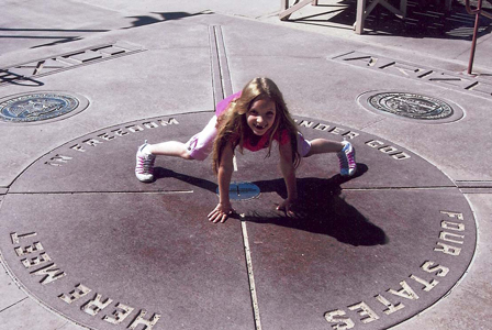 smooth from tourists and visitors standing in the four states in the same time. The brass inscription has had at least one letter replace and the concrete around the rest of the letters was cracked and chipped and was in desperate need of repair. One of the bronze state seals was damaged by vandalism. The tile state names were damaged and replaced, and tile was missing out of the state lines across the top of the monument. The overall condition of the 30-year-old concrete monument was very poor due to foot traffic and deterioration.
During the summer of 1992, the Bureau of Land Management (BLM), from the four states that meet at the Four Corners, joined forces to remonument this important state corner and also rebuilt the existing concrete paving block. The new structure is now encircled by a people-oriented plaza area with bench seats, bronze flag poles, and a handicap access. The top surface of the monument now consists of granite and bronze components set in colored concrete. The center piece is a 5,000 pound, 7 foot diameter by 6-inch thick piece of solid granite with an aluminum-bronze state monument bolted and cemented in the center. This stone bears the inscription that is on the current monument along with engraved state lines. The bronze state seals are mounted in granite and the state names are constructed from solid pieces of granite.
A special public dedication, sponsored by the BLM, the Four Corners Heritage Council, and the Navajo and Ute Mountain Ute Tribal Councils, with representatives from all four adjoining states as well as several federal agencies, was held on October 17, 1992.
BERNTSEN’S ROLE
Berntsen was proud to play a part in the remonumentation of this important point by providing the new bronze tablet to make this point. The new bronze tablet is 8 inches in diameter and about 3 inches thick. To provide for a marker that would have a greater longevity, the new tablet was produced out of a super strong, highly durable, corrosion-resistant aluminum-bronze alloy. To further assure that it would hold up to the many thousands of people touching and standing on it, the inscription on the marker was engraved to a depth of approximately one inch (or about 32 times as deep as the previous marker).
FOR YOUR INFORMATION…
The Four Corners Monument is located ¼ mile west of U.S. Highway 169, six miles north of Teec Nos Pos, Arizona, and forty miles southwest of Cortez, Colorado. Services and accommodations are limited to small cafes, grocery stores, and self-service gasoline stations within a 30-mile radius. Navajo vendors sell handmade jewelry and crafts. Navajo fried bread as well as other traditional foods are available. The Four Corners Monument is part of the Four Corners Monument Navajo Tribal Park and is administered by the Navajo Nation Parks & Recreation Department, within the Division of Natural Resources, whose address is: P.O. Box 308, Window Rock, Arizona 86515. A fee is charged to enter the area. Further information can be obtained by calling the Navajo Nation Parks & Recreation Department at 612-871-6647.
ACKNOWLEDGMENTS
Historical and background information on the Four Corners Monument was provided by Darryl A. Wilson, Chief, Branch of Cadastral Survey, Bureau of Land Management, Colorado State Office, Lakewood, Colorado; and the Navajo Nation Parks & Recreation Department, Window Rock, Arizona.
Originally published in the Berntsen SurveyLog Volume 5, No. 1 (August, 1994)