Berntsen Marks the Census 2000 Center of Population
Each decade, after it tabulates the decennial census, the Census Bureau calculates the nation’s center of population. The center is determined as the place where an imaginary, flat, weightless and rigid map of the United States would balance perfectly if all 281,421,906 residents were of identical weight.
 In 1990 the Center of Population was located in Steelville, Missouri. Berntsen produced a four-inch brass marker to make this point. Once again, Berntsen is proud to have been chosen to produce the decennial Center of Population marker, based on the 2000 Census. This marker was set on April 23, 2001 in Edger Springs (Phelps County), Missouri (population 190), the nearest city to the actual center, approximately 2.8 miles east of Edgar Springs (37.696987 latitude and 91.809567 longitude). This point is approximately 12.1 miles south and 32.5 miles west of the 1990 center of population, which was 9.7 miles southeast of Steelville, Missouri.
The area around Edgar Springs now shares an honor known only to 21 other U.S. Communities as the new U.S. population center. The U.S. Census Bureau has also determined the population centers within each state.
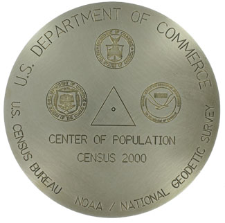
A special 8-inch diameter brass marker was created to mark this important spot. In the ten years since the 1990 marker was set, Berntsen has incorporated exclusive new technology that now can reproduce custom designs and artwork on survey markers. It is because of this technology that the marker design incorporates the design of the 1990 marker as well as the logos of the U.S. Department of Commerce and its two agencies involved in determining and setting the mark ─ the U.S. Census Bureau and the National Oceanic and Atmospheric Administration (NOAA). The National Geodetic Survey (NGS), an agency in NOAA, determined the precise position. The Center of Population marker was set by NGS with cooperation from the U.S. Census Bureau. The Missouri Department of Natural Resources, Phelps County, and the city of Edgar Springs.
Historically, the center of population has followed a trail that reflects the sweep of the nation’s brush stroke across America’s population canvas. The sweep reflects the settling of the frontier, waves of immigration and the migration west and south. Since 1790, the location has moved in a westerly, then a more southerly pattern. The new center of population is now more than 1,000 miles from the first center of 1790, which was located near Chestertown, MD.
In 1980, the center of population was near DeSoto, Missouri, 39.5 miles northeast of the 1990 location. Following the 1950, 1960 and 1970 censuses, the center of population was situated in Illinois: Mascuotah in 1970, Centralia in 1960 and Olney in 1950.
Indiana had the distinction for the previous six decades, from 1890 to 1940. The cities or towns included: Carlisle (1940), Linton (1930), Spencer (1920), Bloomington (1910), Columbus (1900) and Greensburg (1890).
Covington, Kentucky was the population center in 1880. Portsmouth and Hillsboro, Ohio, were the centerpieces in 1870 and 1860, respectively.
In what is now West Virginia, the fulcrum for the nation’s balance from 1830 to 1850 was centered at Parkersburg, Clarksburg and Petersburg, respectively. West Virginia became a separate state in 1863. Until then it was part of Virginia. Moorefield (1820) and Leesburg (1810), Virginia, provided the balance during the previous two censuses. Following the second decennial census in 1800, Baltimore, Maryland, was determined to be the center of population.
Originally published in the Berntsen SurveyLog Volume 12, No. 2 (April, 2001)